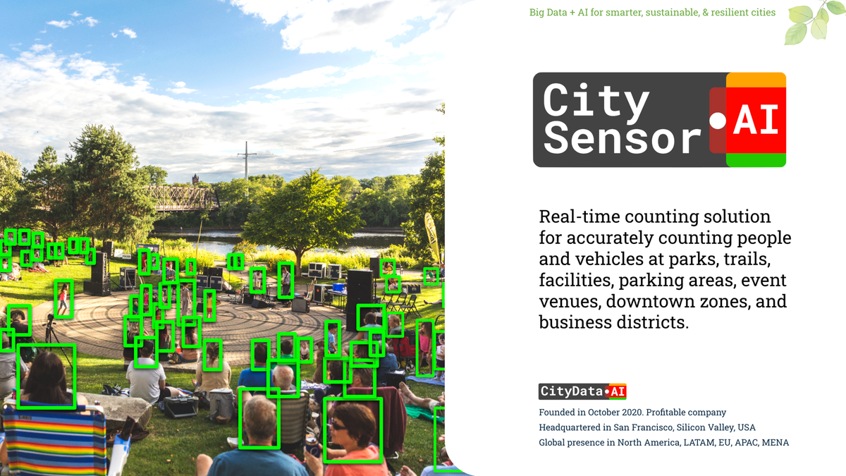
Bridging the Digital and Physical Worlds with CitySensor


From Pixels to Precision: Perfecting ground truth surveys and elevating urban analytics with Computer Vision AI
The Gold Standard of Mobility Intelligence
In an era defined by rapid urbanization and the need for resilient civic planning, municipal agencies face a critical mandate: they must deeply understand how people move, interact, and congregate within their communities.
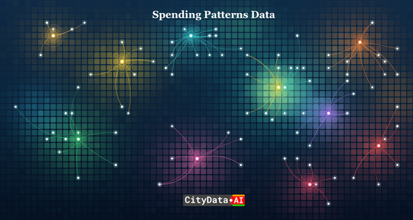
At CityData.AI, we have revolutionized this process by leveraging massive, anonymized, and privacy-compliant crowdsourced mobility datasets. Our proprietary Gravity AI model processes billions of digital mobility signals to infer place visitation and movement patterns, enabling cities to make data-driven decisions.
However, while crowdsourced mobile data provides unprecedented scale and historical depth, it represents a statistical sample of the population rather than an absolute census. To bridge the gap between digital estimations and physical reality, AI models require an unshakeable anchor. This is where the critical science of "ground truthing" comes into play.
Today, we are thrilled to announce the launch of CitySensor, our ultimate ground truth measurement solution designed to perfect urban analytics.
The Absolute Necessity of Ground Truth in AI Modeling
To understand why CitySensor is a game-changer, we must first understand the mechanics of the Gravity AI model. Our platform utilizes advanced spatial interaction frameworks to estimate the flow of people based on the "attractiveness" of a location (like a park or downtown zone) and the "distance" or impedance from a visitor's origin.
While this model is incredibly sophisticated, mobile data penetration rates can vary significantly by region and demographic. Relying solely on mobile application pings leaves blind spots. "Ground truth" refers to real-world verification data collected on-site, such as manual counts, traditional surveys, click-counting, or sensor readings. We use this tangible data to benchmark our digital mobility signals, ensuring that our AI models accurately reflect reality.
By comparing our digital signal counts against your physical ground truth counts, we can calculate a precise "expansion factor". This expansion factor allows us to scale our sample data up to the total population with high confidence. In short, ground truth data acts as the high-confidence calibration layer that transforms intelligent estimations into indisputable facts.
Introducing CitySensor: The Apex of Edge Measurement
To provide this essential layer of physical validation, we engineered CitySensor. CitySensor is available in three distinct formats to suit any municipal use case:
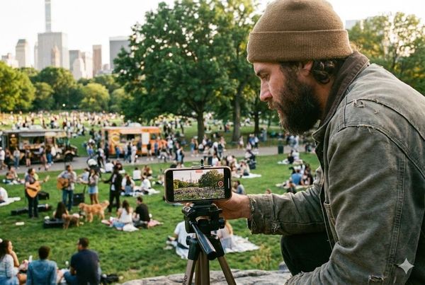
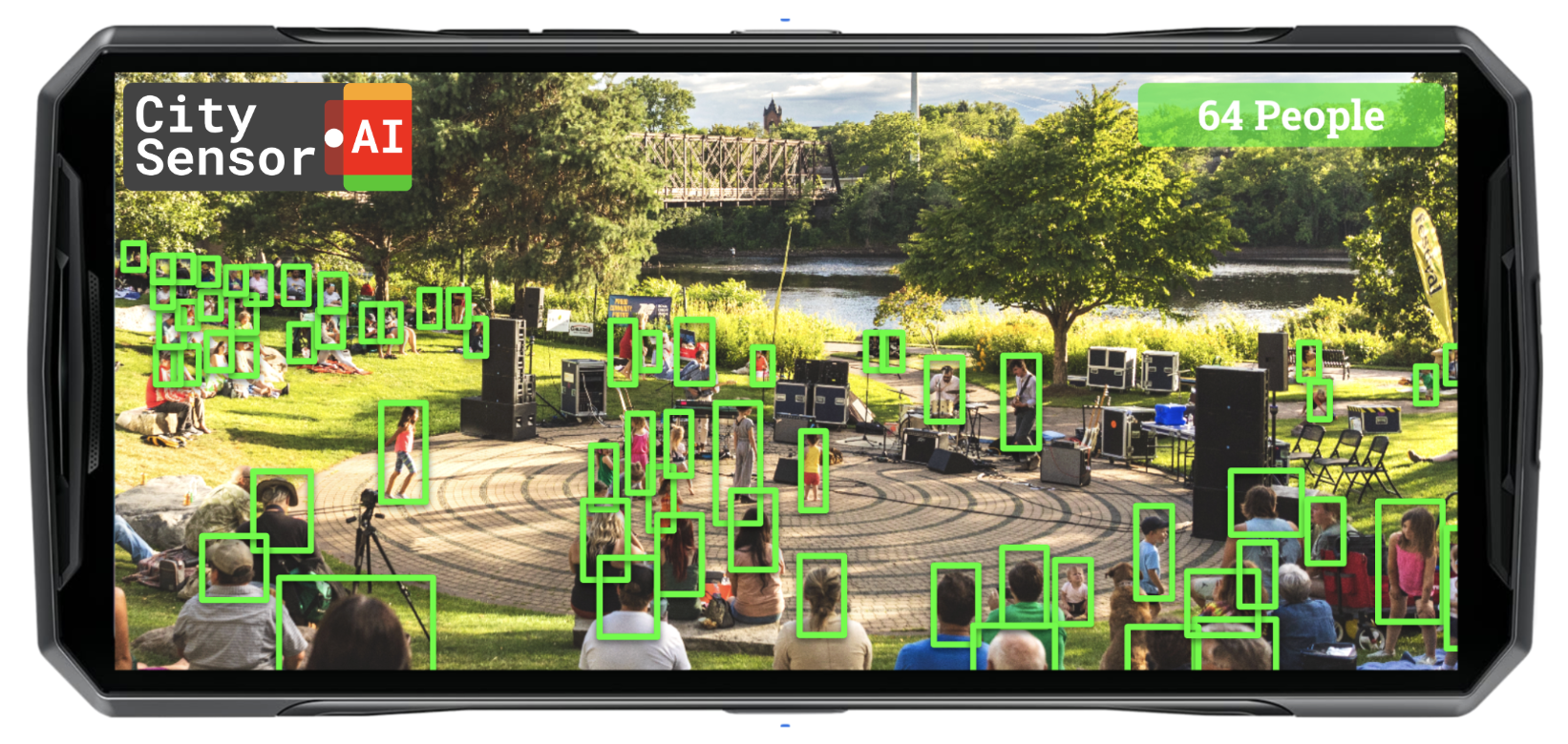
- Free Mobile App: A tool to transform any cell phone into a digital surveying device.
- Rugged Weatherproof Hardware: Designed as a permanent, hardwired counting station.
- Solar-Powered Weatherproof Hardware: A self-sufficient, permanent counting station for remote areas without access to the electrical grid.
For permanent deployments, the hardware sensor represents a massive leap forward in edge-computing capabilities.
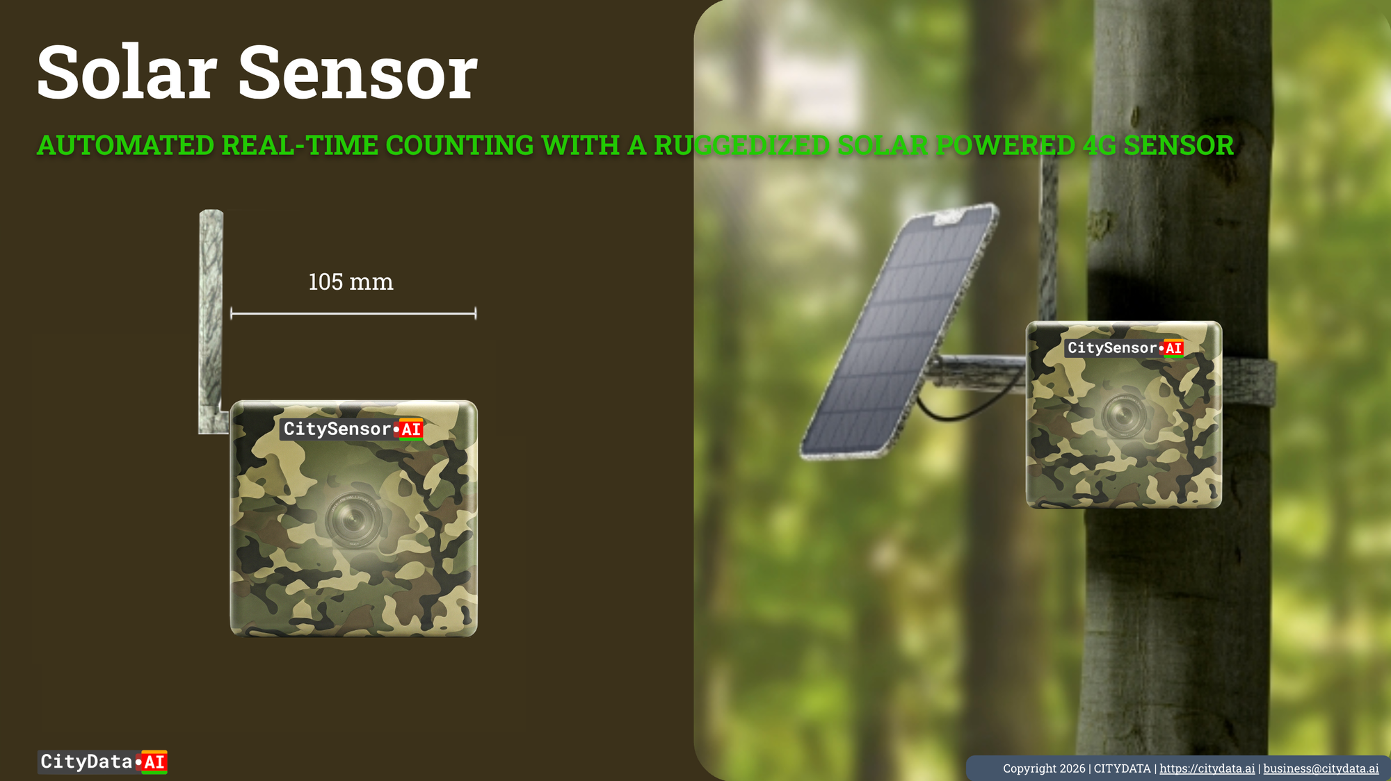
Uncompromising Hardware Built for the Wild
The physical CitySensor device is a military-grade, ruggedized hardware unit built to military MIL-STD-810H compliance standards. It features a Corning Gorilla Glass screen and is IP68 dust-tight and water-resistant, ensuring survival in the most hostile outdoor environments.
Under the hood, the sensor is a computational powerhouse:
- Massive Edge Processing: Equipped with 12 GB of RAM and 512 GB of local storage memory. This massive onboard storage is critical; it ensures offline data continuity during sudden network outages.
- Advanced Connectivity: Telemetry is seamless. The device supports GSM, CDMA, HSPA, LTE, and 5G cellular technology. It also features WLAN Wi-Fi 6, dual-band Bluetooth 5.1, and high-precision GPS.
- High-Resolution Optics: To capture accurate counts in any condition, CitySensor utilizes a Quad Lens 50 MP main camera with an f/2.0 wide aperture. For low-light and nighttime monitoring, it relies on a 64 MP night vision camera featuring dual infrared night vision lights.
Proprietary Computer Vision AI: Precision Without Compromise
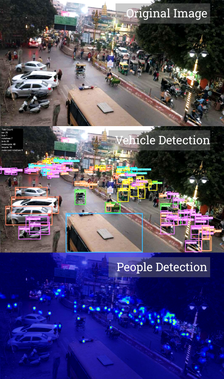
At the core of CitySensor is our state-of-the-art computer vision AI which is pre-trained to detect crowds using a heat map counting approach without relying on facial recognition. It is capable of tracking and counting people, bicycles, cars, vans, buses, trucks, motorcycles, and trains. Furthermore, the system classifies objects into highly specific categories, including SUVs, ORVs, ATVs, tuk-tuks, rickshaws, scooters, and animals/pets. Crucially, the model is also calibrated to detect wheelchairs, allowing cities to identify and track differently-abled persons to ensure inclusive crowd management and facility planning.
Privacy by Design We recognize that public trust is paramount. CitySensor is fully privacy-compliant. Because no video feeds are recorded or transmitted to the cloud, and all image processing happens on the device, no personal data is ever at risk. The sensor does not utilize facial recognition; it merely detects the "shape" and movement of an object. Only numerical count data is transmitted to the cloud.
Empowering Cities with the Custom Data Training Tool While the baseline computer vision AI is extensively pre-trained, we understand that every urban environment has unique characteristics—from specific camera angles to unusual local vehicle types. To achieve inference accuracies beyond 95%, local context training is vital.
Our platform includes a dedicated model training tool that empowers municipal authorities to take control of their AI. City and county officials can select images with lower accuracy, manually label them, annotate specific features, draw bounding boxes, and re-train the AI models using the latest sensor data from their specific location. This custom fine-tuning ensures that the AI continuously adapts to your city's exact physical realities.
The Real-Time Data Dashboard and Weather Correlation
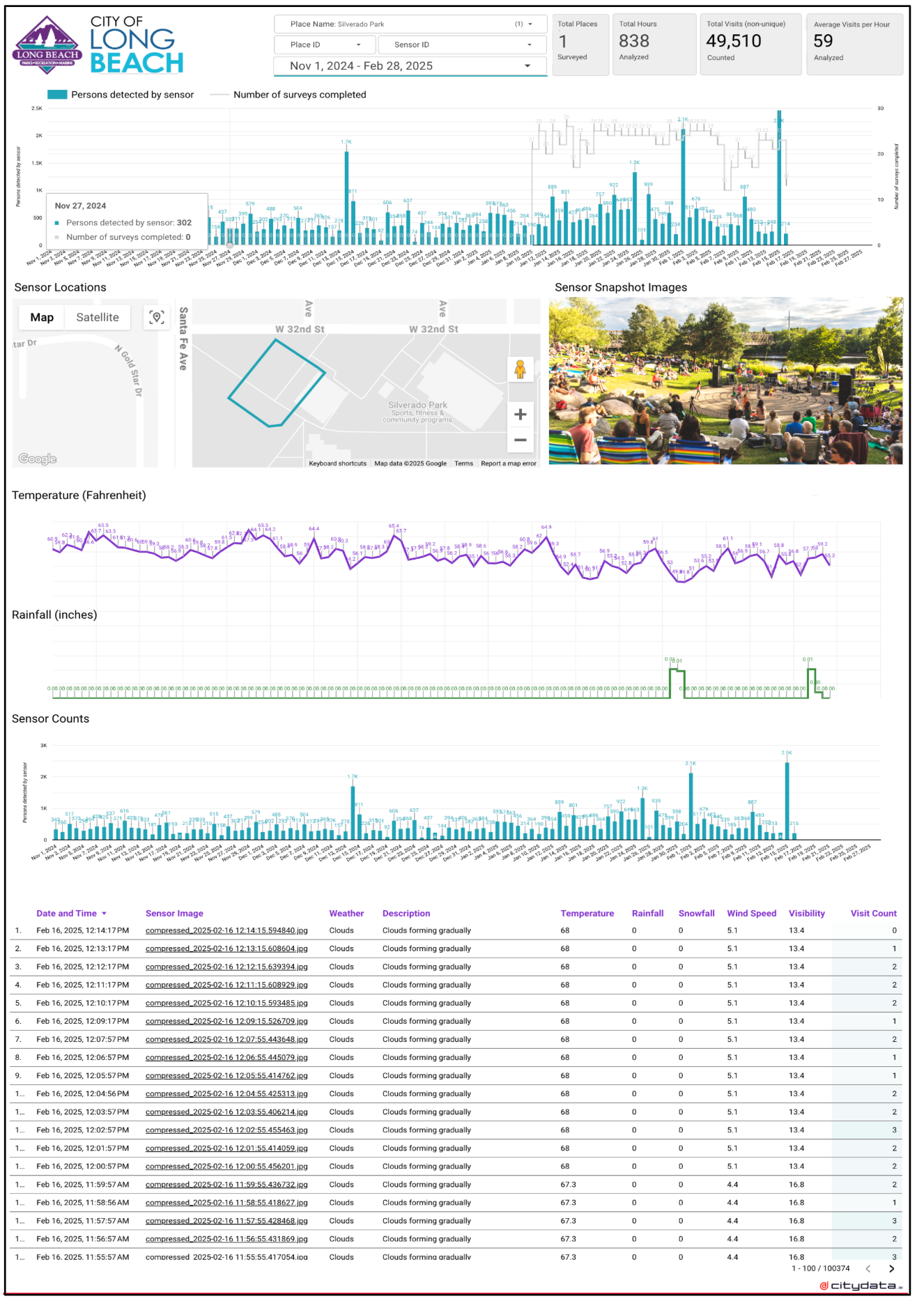
All the telemetry and count data generated by CitySensor flows seamlessly into our online, real-time data dashboard. This platform provides an unparalleled operational view of your monitored spaces.
Through the data analytics dashboard, users can view minute-by-minute counts , as well as aggregated hourly and daily trends. The interface includes time-series charts of visitation , alongside a camera roll of sensor snapshot images.
Because human behavior is deeply tied to environmental conditions, CitySensor goes a step further by correlating footfall counts directly with live weather tracking. The dashboard natively incorporates insights regarding temperature, rainfall, snowfall , humidity, wind speed, and visibility. This allows parks and recreation departments to definitively prove how a sudden drop in temperature or an unexpected rainstorm impacted weekend facility usage.
Low-Touch Operations: Advanced Telemetry and Remote Management
Deploying hardware across a sprawling municipality can often become an administrative burden. CitySensor was engineered to be a low-to-no touch system.
Through our remote management capabilities, administrators have full visibility into the operational health of their network. A specialized remote diagnostics tool allows your team to monitor sensor health—including battery levels, local storage capacity, and 4G/5G network status—in real-time. If a device experiences cellular network latency or a dropped connection, administrators can remotely restart the hardware to force network reconnections without ever dispatching a technician to the field.
Closing the Loop: Supercharging CityParks AI and CityEconomy AI
CitySensor is not just a standalone product; it is the ultimate companion to our broader ecosystem of civic intelligence platforms.
The data collected by the hardware sensor acts as the gold standard of ground truth. This data is automatically ingested into the cloud and converted to ground truth parameters for calibrating and fine-tuning the crowdsourced counting models.
By directly feeding our core Gravity AI model, CitySensor dramatically refines the expansion ratios and improves the accuracy of the visitation insights presented in our CityParks AI and CityEconomy AI platforms. CitySensor validates and re-calibrates the AI models powering all our products, allowing you to combine the massive scale of big data with the surgical precision of on-site measurement.
CitySensor bridges the digital and physical worlds, empowering local governments to make infrastructure, economic, and recreational decisions not with estimations, but with absolute certainty.