Top 13 Questions Asked by Municipal Agencies


About Location-Based Visits and AI Models for Usage Intelligence for Parks, Business Districts, Event Venues
Municipal agencies are increasingly turning to GovTech solutions, geospatial artificial intelligence (AI), and location-based data to build smarter, more resilient cities. However, procuring the right technology requires rigorous vetting. At CityData, we welcome the hard questions because we believe transparency and technological excellence are the foundation of any successful civic partnership.
Here are the top 13 questions municipal agencies ask us before signing a contract for location-based usage intelligence, along with the industry standard answers—and how CityData consistently exceeds expectations to lead the industry.
Part 1: Procurement, Deployment, and Licensing
1. Why are vendors pushing for a sole-source procurement?
- The Industry Standard: Many vendors lobby hard for sole-source designations to avoid side-by-side technical and financial comparisons during a competitive RFP process.
- The CityData Advantage: We embrace open competition because our technology and pricing speak for themselves. We provide a transparent, commercial-off-the-shelf (COTS) SaaS model that controls costs for our clients. Our flexible pricing model is designed to fit government budget cycles, structured around the number of monitored assets and population size, offering predictable budgeting.
2. What does a typical engagement look like? How long before we go live with the data dashboard?
- The Industry Standard: Deployments in the GovTech space can drag on for months, plagued by vague milestones, slow hardware integration, and delayed data processing.
- The CityData Advantage: We provide a structured, highly efficient 5 to 6-week implementation plan from the time of contract signing. Weeks 1 and 2 focus on setup, drawing geofences, and securely ingesting existing GIS shapefiles. During Weeks 3 and 4, we compute visitation counts, calibrate models against ground truth, test hardware, and provide an initial dashboard for review. Finally, in Weeks 5 and 6, we refine the dashboard based on your feedback, deliver the production-ready platform, and conduct comprehensive training for your staff.
3. Is the hardware rated for our specific environment?
- The Industry Standard: Many vendors use off-the-shelf sensors that struggle with extreme weather, solar loading, or remote deployments lacking steady power.
- The CityData Advantage: We offer CitySensor, our proprietary, ruggedized hardware device explicitly designed for permanent outdoor installation. It is flexible regarding power; while it can be hardwired into mains power, we also offer low-power versions that can be deployed with solar panels and battery backups for remote trail locations.
4. Who owns the data after the ink is dry?
- The Industry Standard: Many data brokers try to claim ownership of the mobility data they process for you, attempting to resell your citizens' movement patterns to third-party commercial entities.
- The CityData Advantage: Your data is yours. Your data is strictly siloed and protected. No data products or reports created by City staff are shared with other organizations unless explicitly authorized by the City. Unlike marketing companies, CityData strictly does not collect, provide, or sell citizen data for advertising purposes to brands, fast-food chains, shopping malls, or commercial real estate owners.
5. Are you charging us to access our own information?
- The Industry Standard: A common tactic is "per-seat" or "per-department" licensing, forcing cities to pay escalating fees whenever a new planner or public works official needs access to the dashboard.
- The CityData Advantage: CityData removes all internal barriers by providing an "Unlimited users" licensing model for your organization. You can grant access to as many team members, stakeholders, or inter-departmental colleagues as needed without paying for extra seats. In fact, we actively encourage our municipal customers to share the data dashboards with all internal users to foster collaboration.
6. Can we see your client list and geographic experience?
- The Industry Standard: Most vendors can only provide references from a handful of local "power users" in specific, highly controlled environments.
- The CityData Advantage: CityData is a global entity that serves civic customers internationally. Since our founding in October 2020, our portfolio has grown to include cities, academic institutions, and research organizations across the US, Canada, Mexico, Brazil, the UK, Spain, Italy, France, the UAE, Japan, Australia, and many more. Our platform can activate urban digital twins for virtually any municipality or region in the world.
7. What does the “bad day” data look like? How do you ensure accuracy?
- The Industry Standard: Sales demos only show perfectly sanitized, best-case data. In reality, raw GPS data is incredibly noisy and filled with errors.
- The CityData Advantage: We deploy forensic-level data hygiene. Our algorithms continuously scan for anomalies, identifying issues like "Spoof Location". We actively filter out "Hypervelocity" indicators (physically impossible speed vectors) and "Implausible Movement" (e.g., traveling 5,000 meters in 0 seconds) to ensure your data is rigorously clean before it ever hits your dashboard.
Part 2: AI Models, Data Methodologies, and Privacy
8. How do you extract demographic data for visitors without violating privacy?
- The Industry Standard: Some vendors push the boundaries of privacy to extract demographic profiles directly from individual user devices.
- The CityData Advantage: CityData does not extract demographic data from individuals directly. Instead, we use a privacy-safe inference model to identify the "common evening location" of an anonymized device at the Census Block Group level. We then apply aggregate census data (such as median income, age distribution, and ethnicity) to the visitor profile, providing deep demographic insights without ever accessing personal user profiles.
9. Are you tracking individual users or their specific movements in the cloud?
- The Industry Standard: Questionable data aggregators build detailed profiles on specific people to track their daily routines.
- The CityData Advantage: Privacy is central to our methodology; we do not track individual users or build profiles on specific people. We employ multiple layers of anonymization, hashing mobile device identifiers (MAIDs) and perturbing GPS coordinates. We focus exclusively on aggregate patterns and are fully compliant with stringent privacy legislation like the California Consumer Privacy Act (CCPA).
10. What is "ground truth," and why is it necessary to calibrate AI models?
- The Industry Standard: Many software-only platforms rely blindly on digital signals without verifying them against physical reality.
- The CityData Advantage: We know that mobile data penetration varies by region, which is why "ground truth"—real-world verification data collected on-site—is essential. We use a "ratio-based" calibration method, correlating the number of mobile devices observed with the actual people counted on the ground. To make this easy, we provide the free CitySurvey mobile app and our CitySensor hardware to capture the "Gold Standard" of ground truth data for calibration.
11. How does the AI scale up sample data to represent the entire population?
- The Industry Standard: Basic platforms apply flat, static multipliers that drastically skew results for specific neighborhoods or rural areas.
- The CityData Advantage: We utilize an advanced, machine-learning-based algorithmic scale-up technique. This process aligns our sample trip counts with expected regional population figures by incorporating census data, ground-truth measurements, traffic counters, CCTV feeds, and toll network data. This ensures our insights reflect the true, statistically accurate pulse of the entire metropolitan area.
12. What are the limitations or blind spots in your mobility data?
- The Industry Standard: Vendors often claim 100% perfect visibility, sweeping known demographic blind spots under the rug.
- The CityData Advantage: We are radically transparent about our data. We maintain a strict policy against collecting data from children, and we acknowledge a reduction in data collected from senior citizens due to a drop in mobile app usage among the 65+ cohort. However, we bridge this gap statistically: their presence in parks or commercial areas is inferred based on household composition census data associated with the adult devices that visit the location.
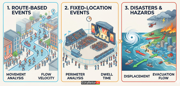
13. How can we use these AI insights for advanced applications like economic development or disaster resiliency?
- The Industry Standard: Location data is often confined to basic foot traffic counts that lack contextual depth for advanced urban planning.
- The CityData Advantage: Our specialized suite of AI products transforms counting into comprehensive urban intelligence. For economic development, our CityEconomy product measures the true heartbeat of business districts by providing granular metrics on footfall and cross-visitation patterns, proving vitality to prospective retailers and measuring downtown recovery. For emergency management, our CityFlow and CitySim products support disaster resiliency by modeling population movement during crises, identifying evacuation bottlenecks, and measuring the displacement of populations during floods or fires.