Decoding Your Downtown: Mobility Intelligence for Economic Vitality

In today's data-driven world, economic development hinges on understanding the intricate visitation and movement patterns within our cities. To truly revitalize downtown zones, commercial areas, and business districts, cities need to understand the intricate dance of human movement. Mobility intelligence provides the detailed choreography, transforming raw data into actionable insights that empower economic developers to revitalize our cities.
Unveiling the Economic Narrative
Cities face the ongoing challenge of supporting local businesses, fostering vibrant commercial spaces, and attractive new investments. Traditional methods of measuring economic activity, like sales figures or manual counts, offer limited insights. These indicators represent a static snapshot rather than a dynamic understanding of urban activity. We need a more granular and dynamic approach to quantify visitation and movement trends.
Mobility Intelligence: A Data-Driven Solution
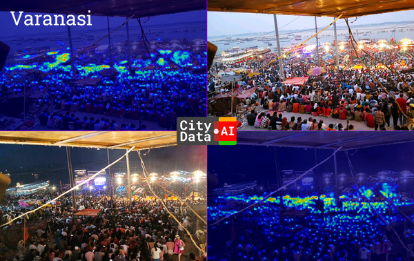
Mobility intelligence, leveraging anonymized, aggregated data from diverse sources, provides a comprehensive view of how people interact with commercial areas. This data allows for:
- Precise Visitation Quantification:
- Moving beyond estimations, we can accurately measure foot traffic, dwell times, and peak visitation periods.
- This data reveals the true economic pulse of our commercial zones.
- Detailed Movement Pattern Analysis:
- Understanding how people navigate within and between districts reveals key corridors, bottlenecks, and connectivity patterns.
- This allows for informed decisions on infrastructure, zoning, and urban planning.
- Attracting Investment and Business:
- Data-backed insights demonstrate the potential for growth, attracting new businesses and investment.
- Quantifiable evidence of customer flow enhances the appeal of commercial locations.
- Measuring the Impact of Initiatives:
- Evaluate the effectiveness of redevelopment projects, marketing campaigns, and public space improvements.
- Track changes in visitation and movement to optimize economic development strategies.
- Supporting Local Business Growth:
- Provide businesses with valuable data on customer behavior, peak hours, and demographics.
- Empower businesses to make informed decisions and enhance their operations.

Methodology and Implementation
To achieve these insights, a robust methodology is essential, similar to that outlined in the original park-focused blog post:
- Data Collection:
- Gather anonymized mobility data from various sources including GPS, WiFi, Bluetooth, IoT sensors, and connected cars, ensuring compliance with local and regional privacy regulations.
- Establish a continuous, high-quality mobility data stream.
- Data Processing and Analysis:
- Filter and cleanse data to ensure accuracy and reliability.
- Utilize geohashing and hexagonal grid systems for precise location analysis.
- Apply spatiotemporal shifts to further protect privacy.
- Combine mobility data with GIS data, demographic information, spend patterns data, and other relevant datasets.
- Employ machine learning algorithms to identify visitation patterns and movement trends.
- Set visit parameters based on the size and type of the commercial area.
- Infer home and work neighborhoods to scale data based on census population counts.
- Visualization and Reporting:
- Present data through interactive dashboards and visualization tools.
- Integrate data with existing city systems and platforms.
- Share insights with stakeholders and decision-makers.
- Prepare cloud datastores for querying data using SQL.
- Create APIs for accessing the data.

Key Applications for Economic Development
- Downtown revitalization: Cities can use mobility data to identify areas with declining foot traffic and develop targeted revitalization strategies. For example, a city might discover that a specific street has low evening traffic, prompting them to invest in lighting, public art, or evening events.
- Commercial corridor analysis: Cities can evaluate the performance of retail and restaurant corridors. For example, a city might use data to identify a corridor with high daytime traffic but low evening traffic, prompting them to encourage the development of evening entertainment options.
- Event impact assessment: Cities can measure the economic impact of festivals, events, and conferences. For example, a city might use data to track the increase in foot traffic and spending in surrounding businesses during a major festival.
- Supporting small businesses: Mobility data can provide valuable insights to small businesses. For example, a restaurant might use data to identify peak hours and optimize staffing levels.
Real-World Success Stories
- Thornton, Colorado: Crafting Commerce with Precision.Rather than relying on mere intuition, Thornton has adopted a data-centric approach to its economic strategy. By meticulously tracking visitation patterns within its retail hubs, urban core, and strategically defined commercial zones, the city gains a clear, quantifiable understanding of its economic pulse. This allows for the precise calibration of policies, ensuring resources are directed where they yield maximum impact.
- Cedar Hill, Texas: Data as the Architect of Prosperity.In Cedar Hill, economic growth isn't a matter of chance; it's a carefully engineered outcome. By dissecting mobility data, the city transforms abstract trends into concrete metrics. These insights serve as the bedrock for policy decisions, empowering officials to cultivate a thriving environment for local enterprises.
- Tolleson, Arizona: Rebuilding Downtown's Heartbeat, Digitally.Tolleson has witnessed a tangible resurgence in its downtown core, fueled by the analytical power of mobility intelligence. By quantifying the city’s post-recovery foot traffic, city officials are able to make informed decisions regarding urban renewal. Budget allocations and strategic revitalization efforts are now driven by real time data, and not estimations.
- Wilsonville, Oregon: Engineering Economic Landscapes with Mobility Metrics.Wilsonville has elevated its economic planning to an art form, leveraging mobility data to sculpt its policies with meticulous detail. By dissecting visitation trends within its urban center, business improvement zones, and designated commercial spaces, the city gains a deep understanding of consumer behavior. This allows them to create an economic ecosystem that encourages growth.
- Tukwila, Washington: Fostering Collaborative Growth Through Data Transparency.Tukwila's approach is marked by its commitment to sharing insights beyond the city walls. By disseminating mobility data to local business leaders and key stakeholders, the city fosters a collaborative environment where everyone is empowered to make informed economic decisions. This transparency transforms raw data into a shared resource, driving collective prosperity.
- Singapore Pools: Strategic Site Selection, Powered by Movement Analytics.Rather than relying on conventional market research, Singapore Pools employs sophisticated mobility analysis to discern visitation trends at existing locations. This allows them to accurately gauge demand and forecast the potential performance of prospective new sites. By strategically placing their facilities, they ensure equitable access for all residents, optimizing their network through data-driven precision.
- Barcelona, Spain: Reimagining Urban Spaces Through Pedestrian-Centric Data.Barcelona's urban transformation is a testament to the power of mobility intelligence in shaping cityscapes. The city's innovative "superblocks," designed to prioritize pedestrian flow and cultivate vibrant public spaces, are informed by detailed movement analysis. This approach allows Barcelona to understand the real-world impact of urban design changes on local commerce and the overall flow of city life, ensuring that development enhances, rather than hinders, the urban experience.
- Copenhagen, Denmark: Cycling Towards Economic Vitality, Guided by Mobility Insights.Copenhagen's commitment to pedestrian and bicycle infrastructure is underpinned by meticulous mobility data analysis. By tracking movement patterns, the city gains critical insights that inform infrastructure development, fostering a sustainable and economically vibrant urban environment. This data allows Copenhagen to quantify the tangible economic benefits of increased pedestrian and bicycle traffic within its commercial zones, demonstrating the direct correlation between sustainable infrastructure and economic prosperity.
The Future of Economic Development
Mobility intelligence is not just a tool; it's a paradigm shift. By embracing data-driven decision-making, economic development professionals can gain a deeper understanding of their cities and create more vibrant, equitable, and prosperous communities.
In the modern age, economic development is no longer a game of guesswork. We hope this blog post offered you a comprehensive and compelling exploration of the role of mobility intelligence in measuring, sustaining, and accelerating economic growth in our cities.
About CITYDATA.ai
CITYDATA.ai brings mobility big data + AI to make cities smarter, sustainable, and more resilient. We provide insights about people counts, density patterns, movement trends, economic impact, and community engagement.
Founded in 2020 in San Francisco, California, CITYDATA.ai provides fresh, accurate, daily insights that are essential for smart city programs, economic development, urban planning, mobility and transportation, tourism, parks and recreation, disaster mitigation, sustainability, and resilience.
You can reach us via email at business@citydata.ai if you’d like to discuss your data needs and use cases. You can also follow the company on Linkedin, and subscribe to our blog to stay updated on the newest innovations in big data and AI for the public sector.